For thousands of years, archaeology meant one thing: digging. Teams of researchers would spend months, sometimes years, carefully excavating a site layer by layer, hoping to uncover something meaningful beneath the earth. It was slow, expensive, and often destructive. Once a site was disturbed, there was no going back.
But that image of archaeology dusty trenches, brushes, and hand tools is rapidly changing. A new generation of technology is transforming how we find, study, and preserve the remnants of ancient civilizations. At the center of this transformation is drone technology, and its impact on the field is nothing short of revolutionary.
Seeing What the Eye Cannot
The most immediate advantage drones bring to archaeology is perspective. From the ground, even an experienced archaeologist can only see what is directly in front of them. From the air, patterns emerge that would be completely invisible at ground level.
Ancient roads, buried foundations, irrigation channels, and ceremonial structures often leave subtle marks on the landscape slight differences in soil color, variations in vegetation density, or faint geometric outlines that are only recognizable from above. Archaeologists have known about these aerial signatures for decades, but capturing them used to require expensive aircraft or satellite imagery that was either too costly or too low in resolution to be truly useful.
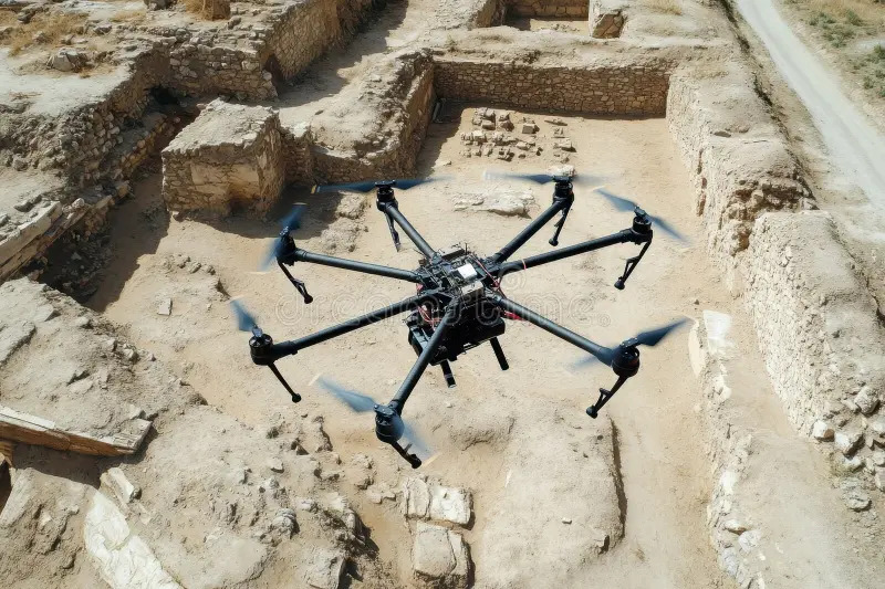
Drones changed that equation entirely. A modern drone equipped with a high-resolution camera can fly at low altitudes and capture imagery with extraordinary detail. What might have taken weeks of planning and significant budget to achieve with a manned aircraft can now be done in an afternoon. The result is faster site discovery, better data, and far less disruption to the landscape.
LiDAR: Seeing Through Trees and Time
Perhaps the most powerful tool in the modern archaeological drone’s arsenal is LiDAR – Light Detection and Ranging. This technology works by emitting thousands of laser pulses per second and measuring how long it takes for each pulse to bounce back. The result is an incredibly detailed three-dimensional map of whatever lies below.
What makes LiDAR so remarkable for archaeology is its ability to penetrate dense vegetation. In jungle environments like Central America or Southeast Asia, entire ancient cities have remained hidden beneath forest canopies for centuries – not because no one was looking, but because traditional survey methods simply could not see through the trees. LiDAR can.
In recent years, LiDAR surveys conducted from drones have revealed enormous ancient urban networks in Guatemala, Cambodia, and the Amazon basin. Cities that researchers had estimated to be modest settlements turned out to be sprawling metropolises with complex road systems, water management infrastructure, and thousands of structures. These discoveries did not require a single shovel. They were made from the sky.
Professional drone archaeology services now routinely deploy LiDAR alongside thermal imaging and multispectral cameras, giving archaeological teams a comprehensive view of a site before any physical work begins. This means excavation plans are better informed, resources are used more efficiently, and the risk of accidentally damaging important features is dramatically reduced.
Mapping With Precision: 3D Models and Digital Terrain Data
Beyond raw discovery, drones are also transforming how archaeological sites are documented and studied. Using photogrammetry a process that stitches together hundreds of overlapping aerial photographs drones can produce highly accurate 3D models of entire sites. These models capture surface details at millimeter precision and can be used to create digital terrain models, orthomosaic maps, and CAD drawings that archaeologists use for planning, publication, and preservation.
These digital records are also invaluable for long-term site monitoring. Over time, archaeological sites can be damaged by erosion, development, looting, or climate change. By conducting repeat drone surveys, researchers can track changes to a site across months and years, identifying threats before they cause irreversible damage. The drone becomes not just a discovery tool, but a preservation tool.
Less Destruction, More Discovery
One of the most significant shifts that drone technology has enabled is a move toward non-invasive archaeology. Traditional excavation permanently alters a site. Once soil is removed, the context it held is gone forever.
Drones support a less destructive approach. By providing detailed surface data, aerial imaging, and subsurface mapping, researchers can build a comprehensive picture of a site without ever breaking ground. This approach is especially important at protected or sensitive sites where physical intervention is restricted by law or ethical considerations. Sacred sites, burial grounds, and legally protected locations can now be studied in depth without violating those restrictions.
The Right Pilot for the Job
The quality of a drone archaeological survey depends heavily on the experience and qualifications of the operator. Archaeological drone work is not simply a matter of flying over a field and taking photos. It requires an understanding of sensor calibration, flight path planning, data processing, and the specific outputs that archaeological teams need.
Anyone looking to hire a drone pilot for this kind of specialized work should verify that the operator has relevant experience with archaeological or geospatial surveys, is familiar with LiDAR and multispectral cameras, and can deliver data in formats compatible with GIS software and academic documentation standards.
Licensing and compliance also matter. A professional operator will handle airspace authorization, manage safety protocols, and ensure the survey is conducted within legal boundaries particularly important when working at protected heritage sites.
Real World Discoveries That Changed History
The results speak for themselves. In Peru, drone surveys over the Nazca Lines have produced the most detailed maps ever created, revealing previously unknown figures. In Jordan, aerial surveys have identified hundreds of ancient structures in desert regions that would have taken decades to locate through ground exploration alone. In Italy, drones equipped with thermal imaging have detected buried Roman roads and villa complexes beneath agricultural fields.
Most dramatically, a LiDAR survey in northern Guatemala revealed that the ancient Maya civilization was far larger and more complex than previously believed more than 60,000 previously unknown structures identified across 2,100 square kilometers. It was one of the most significant archaeological discoveries of the modern era, and it was made without excavating a single cubic meter of earth
A New Chapter in Human History
The aerial drone survey is not simply a new tool for an old discipline. It represents a fundamental shift in what is possible sites that would have remained hidden for generations are now being found, and civilizations that history had forgotten are being remembered.
Archaeology has always been about asking questions of the past. Drone technology has lowered the barriers to discovery while raising the standards for documentation and preservation. It is rewriting history, one flight at a time.
Buy Me A Coffee
The Havok Journal seeks to serve as a voice of the Veteran and First Responder communities through a focus on current affairs and articles of interest to the public in general, and the veteran community in particular. We strive to offer timely, current, and informative content, with the occasional piece focused on entertainment. We are continually expanding and striving to improve the readers’ experience.
© 2026 The Havok Journal
The Havok Journal welcomes re-posting of our original content as long as it is done in compliance with our Terms of Use.